
Low Earth vs Geostationary Orbit: How to Choose the Right Orbit
Compare low Earth orbit (LEO) and geostationary orbit (GEO) by altitude, orbital speed, period, and coverage. Learn how to calculate orbital properties and justify the best orbit for communication, Earth observation, and continuous satellite coverage.
One satellite crosses the night sky and disappears behind the horizon after a few minutes. Another can deliver a television signal to the same ground dish all day without the dish tracking it. Which satellite is moving faster, and which orbit would you choose for detailed Earth images?
The lower satellite is generally faster and completes each orbit sooner. The apparently stationary satellite is much higher, moves more slowly along its orbit, and takes almost 24 hours to complete one revolution. The difference comes down to how each orbit interacts with Earth’s rotation.
Match the orbit to the mission
| Low Earth orbit (LEO) | Altitude: 160–2,000 km Period: 88–127 min; speed: 7.0–7.8 km/s Smaller, moving footprint; brief passes over ground stations Applications: Earth imaging, polar observation, communication constellations |
|---|---|
| Geostationary orbit (GEO) | Altitude: 35,786 km above the equator Period: 23 h 56 min; speed: 3.07 km/s Broad, fixed footprint; poor polar coverage Applications: TV broadcasting, fixed communications, weather monitoring |
01The quick decision rule
Start with the job the satellite must do.
- Choose low Earth orbit (LEO) when you need detailed images of Earth’s surface, relatively short signal travel distances, or access to polar regions. Expect a satellite to move across the sky and provide only temporary coverage of a particular ground station. Continuous service usually requires a constellation.
- Choose geostationary orbit (GEO) when you need continuous communication with a fixed ground station or repeated observations of the same broad region. The satellite appears stationary relative to Earth, so a ground dish can point in a fixed direction.
- Choose a constellation rather than relying on one satellite when the job requires continuous coverage across a large area, particularly at high latitudes, or when frequent observations are needed.
The best orbit is not simply the highest or fastest one. You need to match altitude, orbital period, speed, coverage, and the mission’s requirements.
02LEO vs GEO: the reference table
| Feature | Low Earth orbit (LEO) | Geostationary orbit (GEO) |
|---|---|---|
| Altitude above Earth’s surface | Roughly 160-2,000 km | About 35,786 km |
| Orbital period | About 88-127 minutes | One sidereal day: 23 h 56 min 4 s |
| Orbital speed | Approximately 7.0-7.8 km/s | Approximately 3.07 km/s |
| Position relative to a ground observer | Moves across the sky | Appears at a fixed position in the sky |
| Ground coverage | Relatively small, moving footprint | Broad, approximately fixed footprint |
| Main advantage | Close observation, relatively low signal travel time, and potential polar access | Continuous coverage of a fixed region within its footprint |
| Main limitation | Brief passes and gaps in coverage from a single satellite | Greater signal delay and poor coverage near the poles |
| Typical applications | Earth imaging, environmental monitoring, and low-latency communications constellations | Television broadcasting, fixed satellite communications, and weather monitoring |
These values are approximate. LEO’s altitude boundaries vary slightly between definitions, and its period and speed depend on the orbit’s altitude. GEO figures assume a circular, equatorial, prograde orbit.
One distinction is essential: altitude is measured from Earth’s surface, but orbital equations use distance from Earth’s centre. We will use \(h\) for altitude and \(r\) for orbital radius, so
\[ r=R_E+h \]
where \(R_E\) is Earth’s equatorial radius, approximately \(6.378\times10^6\ \mathrm{m}\).
03Why does a lower satellite move faster?
Imagine two satellites travelling in circular orbits around Earth. One is close to Earth, and the other is much farther away.
The closer satellite experiences a stronger gravitational pull. For a circular orbit, it needs a higher speed to maintain that tighter curve. The satellite farther away experiences weaker gravity and has a lower circular orbital speed.
There is an important detail here: a satellite cannot independently choose any speed and remain in the same circular orbit. Its speed must be consistent with the gravitational force at that radius.
The two equations you need
For a circular orbit, gravity supplies the centripetal force required to keep the satellite moving in a circle.
\[ \frac{GM_E m}{r^2}=\frac{mv^2}{r} \]
Here:
- \(G\) is the universal gravitational constant.
- \(M_E\) is Earth’s mass.
- \(m\) is the satellite’s mass, in kilograms.
- \(r\) is the orbital radius, measured from Earth’s centre, in metres.
- \(v\) is the satellite’s orbital speed, in metres per second.
The satellite’s mass cancels from both sides. Rearranging gives the circular orbital speed:
\[ v=\sqrt{\frac{GM_E}{r}} =\sqrt{\frac{\mu}{r}} \]
We have defined \(\mu=GM_E\), Earth’s standard gravitational parameter, which is approximately \(3.986\times10^{14}\ \mathrm{m^3\,s^{-2}}\).
The orbital period \(T\) is the time taken to complete one full revolution. A circular orbit has circumference \(2\pi r\), so
\[ T=\frac{2\pi r}{v} \]
Substituting the speed equation gives
\[ T=2\pi\sqrt{\frac{r^3}{\mu}} \]
Here, \(T\) is measured in seconds.
Both equations assume a circular orbit and neglect effects such as atmospheric drag and Earth’s departures from a perfect sphere.
Read the equations before choosing a formula
The equations reveal two opposite trends:
- As \(r\) increases, \(v\) decreases.
- As \(r\) increases, \(T\) increases.
In proportional form,
\[ v\propto r^{-1/2} \qquad T\propto r^{3/2} \]
A higher satellite travels more slowly, but it must cover a much larger circumference. Both effects contribute to its longer orbital period.
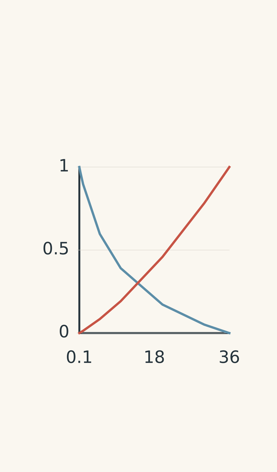
- Speed (normalised)
- Period (normalised)
Notice that orbital speed and apparent movement across the sky are not quite the same thing. Orbital speed measures distance travelled per second along the orbit. Apparent movement describes how the satellite’s direction changes for a ground observer. The difference becomes particularly important when we consider GEO.
04Why does a geostationary satellite appear stationary?
A satellite in GEO is not hovering in space. It is moving continuously under gravity, just like a satellite in LEO.
The difference is that its orbital motion matches Earth’s rotation.
For a satellite to be geostationary, it must satisfy all four conditions:
- It follows a circular orbit.
- Its orbit lies in Earth’s equatorial plane.
- It travels eastward, in the same direction as Earth’s rotation.
- Its orbital period equals one sidereal day, approximately 23 hours, 56 minutes, and 4 seconds.
The last condition is especially important. A sidereal day measures Earth’s rotation relative to distant stars. It is slightly shorter than a 24-hour solar day because Earth also moves along its orbit around the Sun.
How the matching motion works
Picture the point on Earth’s equator directly beneath the satellite. As Earth rotates eastward, that point moves eastward too.
The satellite also moves eastward, with the same angular speed. Because both complete one rotation in the same time, the satellite stays above approximately the same longitude.
Why a geostationary satellite appears stationary
- Satellite orbits eastward
Its path is circular and lies in Earth’s equatorial plane.
- Earth rotates eastward
The ground beneath the satellite rotates in the same direction.
- Rotation periods match
Both complete one rotation in one sidereal day: about 23 h 56 min 4 s.
- Angular positions stay aligned
Their matching angular speeds keep the satellite above approximately the same longitude.
- Satellite appears stationary
A ground observer sees it at a fixed position in the sky; it is still moving in orbit.
The satellite’s orbital speed is about \(3.07\ \mathrm{km\,s^{-1}}\), much lower than a typical LEO satellite’s speed. It still travels a considerable distance, but its motion keeps pace with Earth’s rotation.
A ground dish can therefore point in a fixed direction and maintain contact with the satellite, provided the ground station lies within its coverage area.
Geosynchronous is not always geostationary
These two terms are related, but they are not interchangeable.
A geosynchronous satellite has an orbital period equal to one sidereal day. However, its orbit may be inclined or elliptical.
An inclined orbit makes the satellite’s position move north and south relative to the equator. An elliptical orbit makes its speed vary along the path, causing its apparent position to shift east and west as well.
A geostationary satellite is the special case that is circular, equatorial, prograde, and synchronised with Earth’s rotation. It appears fixed relative to the ground.
This is why simply finding a satellite with a period of approximately 24 hours is not enough to establish that it is geostationary.
05Coverage: which parts of Earth can a satellite see?
Orbital period and speed tell you how a satellite moves. They do not, by themselves, tell you whether it can provide the coverage a mission needs.
A satellite’s footprint is the region of Earth it can serve or observe. Its size depends on altitude and geometry, as well as the satellite’s antenna or sensor.
GEO: broad, fixed coverage
GEO’s great altitude gives it a wide view of Earth. In ideal geometry, one GEO satellite has line of sight to roughly 42% of Earth’s surface. Its actual service area is smaller because antenna beams, terrain, and minimum usable signal elevation impose additional limits.
There is a useful geometric check for high-latitude coverage.
Treat Earth as a sphere. At the horizon, the line from the satellite to the ground is tangent to Earth. If \(\psi_{\max}\) is the maximum central angle between the point directly beneath the satellite and the horizon, then
\[ \psi_{\max}=\cos^{-1}\left(\frac{R_E}{r}\right) \]
For GEO, the orbital radius is approximately \(42{,}164\ \mathrm{km}\). Therefore,
\[ \begin{aligned} \psi_{\max} &=\cos^{-1}\left(\frac{6378}{42164}\right)\\ &\approx81.3^\circ \end{aligned} \]
This angle explains why GEO struggles with polar coverage. A satellite above the equator cannot see the poles because Earth blocks the line of sight.
Even at lower latitudes, a ground station near the edge of the footprint sees the satellite close to the horizon. Practical communication can become unreliable before the geometric horizon is reached.
LEO: smaller, moving coverage
A LEO satellite sees a smaller region at any one time. As it travels around Earth, its footprint moves across the surface.
A ground station may receive a strong signal while the satellite is above its horizon, then lose contact as the satellite moves away. The satellite continues around Earth, but it does not remain above that station.
A polar LEO orbit can pass over high-latitude regions, making it useful for observing the poles. However, one polar-orbiting satellite still provides intermittent coverage of a particular station. A constellation of suitably spaced satellites can provide more frequent or continuous coverage through overlapping footprints and handovers.
06Match the orbit to the mission
Altitude, speed, and coverage combine to produce different advantages. Use the mission requirement to decide which matters most.
Continuous broadcasting and communication
For broadcasting to fixed dishes across Australia, GEO is usually the natural choice. A satellite can remain above the same longitude and cover a broad region, so the dish does not need to track a rapidly moving satellite.
The trade-off is signal travel time. GEO’s greater distance introduces more propagation delay than a comparable LEO link. For interactive communications, this can matter.
LEO communication systems reduce the distance to an individual satellite, but a network must manage changing satellite positions, handovers, and gaps in coverage.
High-resolution Earth observation
For detailed images of a bushfire, a flood, or a changing coastline, LEO is often preferable.
The satellite is much closer to the surface. For otherwise comparable imaging systems, this can make it easier to resolve smaller ground features. Actual resolution also depends on the sensor, optics, and observation conditions.
The limitation is that a single satellite does not continuously observe the same location. Its orbit determines when it passes over the target, so repeat observations depend on the orbit, the satellite’s viewing geometry, and whether additional satellites are available.
Weather monitoring
For continuously watching the same broad region, GEO is particularly useful. A weather satellite can observe cloud systems developing and moving across its field of view without repeatedly passing out of view of the region.
LEO weather satellites offer different advantages, including closer observations and access to polar regions. They are valuable when the mission needs coverage that a fixed equatorial satellite cannot provide.
07Worked example: calculate the speed and period of a LEO satellite
An Earth-observation satellite moves in a circular orbit 400 km above Earth’s surface. Estimate its orbital speed and period.
Use \(R_E=6.378\times10^6\ \mathrm{m}\) and \(\mu=3.986\times10^{14}\ \mathrm{m^3\,s^{-2}}\).
Step 1
The equations use distance from Earth’s centre, not altitude alone.
\[ \begin{aligned} r&=R_E+h\\ &=6.378\times10^6+4.00\times10^5\\ &=6.778\times10^6\ \mathrm{m} \end{aligned} \]
Step 2
Because the satellite is in a circular orbit, use \(v=\sqrt{\mu/r}\).
\[ \begin{aligned} v&=\sqrt{\frac{\mu}{r}}\\ &=\sqrt{\frac{3.986\times10^{14}}{6.778\times10^6}}\\ &\approx7.67\times10^3\ \mathrm{m\,s^{-1}}\\ &=7.67\ \mathrm{km\,s^{-1}} \end{aligned} \]
Step 3
\[ \begin{aligned} T&=2\pi\sqrt{\frac{r^3}{\mu}}\\ &\approx5.55\times10^3\ \mathrm{s}\\ &\approx92.6\ \mathrm{min} \end{aligned} \]
The satellite completes an orbit in about 92.6 minutes while travelling at approximately \(7.67\ \mathrm{km\,s^{-1}}\). Its period is far shorter than a sidereal day, so it cannot remain above one longitude as Earth rotates.
08Worked example: find the altitude of a geostationary satellite
A communications satellite must remain above the same longitude. Determine the orbital radius, altitude, and orbital speed required for a circular geostationary orbit.
Use a sidereal period of \(T=86{,}164\ \mathrm{s}\).
Step 1
For a geostationary orbit, the satellite must complete one revolution in one sidereal day. The circular-orbit period equation is
\[ T=2\pi\sqrt{\frac{r^3}{\mu}} \]
Rearrange it to make \(r\) the subject:
\[ r=\left(\frac{\mu T^2}{4\pi^2}\right)^{1/3} \]
Step 2
\[ \begin{aligned} r^3&=\frac{\mu T^2}{4\pi^2}\\ &=\frac{(3.986\times10^{14})(86164)^2}{4\pi^2}\\ r&\approx4.2164\times10^7\ \mathrm{m}\\ &=42{,}164\ \mathrm{km} \end{aligned} \]
Step 3
Subtract Earth’s equatorial radius.
\[ \begin{aligned} h&=r-R_E\\ &=42{,}164-6{,}378\\ &=35{,}786\ \mathrm{km} \end{aligned} \]
Step 4
The satellite travels one circumference in one orbital period.
\[ \begin{aligned} v&=\frac{2\pi r}{T}\\ &=\frac{2\pi(4.2164\times10^7)}{86164}\\ &\approx3.07\times10^3\ \mathrm{m\,s^{-1}}\\ &=3.07\ \mathrm{km\,s^{-1}} \end{aligned} \]
The satellite must orbit about \(35{,}786\ \mathrm{km}\) above Earth’s equator at approximately \(3.07\ \mathrm{km\,s^{-1}}\). Its lower orbital speed does not prevent it from covering a much larger circumference; the resulting period matches Earth’s sidereal rotation.
The calculated altitude is not sufficient on its own. The satellite must also follow a circular, equatorial, prograde orbit.
09Common mistakes
- Using altitude instead of orbital radius. The gravitational equations use \(r=R_E+h\), because gravity acts relative to Earth’s centre. Substituting \(h\) directly gives the wrong result.
- Assuming a higher satellite travels faster. Circular orbital speed decreases as orbital radius increases. GEO is slower than LEO, even though it travels around a much larger circle.
- Calling every 24-hour satellite geostationary. The required period is one sidereal day, not exactly 24 hours. The orbit must also be circular, equatorial, and prograde.
- Assuming GEO covers the whole Earth. Earth blocks the line of sight to polar regions. A broad footprint is not the same as global coverage.
- Confusing orbital period with contact time. A LEO satellite may take about 90 minutes to orbit Earth but remain visible to one ground station for only a small fraction of that time.
- Assuming every LEO orbit reaches the poles. Polar access depends on orbital inclination, not simply altitude.
10Questions and solutions
Question 1
A satellite follows a circular orbit with an orbital period of 100 minutes. It passes over a ground station and then disappears below the horizon.
Is the satellite in LEO or GEO? Explain whether a fixed ground dish can maintain contact with it throughout its orbit.
Solution 1
The satellite is in LEO, and a fixed ground dish cannot maintain contact with it throughout its orbit.
A period of 100 minutes is consistent with LEO, where typical orbital periods range from roughly 88 to 127 minutes. GEO requires a period of approximately 23 hours and 56 minutes, together with the correct orbital orientation.
The LEO satellite moves relative to Earth’s surface and eventually passes below the ground station’s horizon. The dish would need to track the satellite during a pass, and the station would lose contact when the satellite moves out of view. Continuous service would generally require additional satellites or another communication path.
Question 2
Two satellites follow circular orbits at altitudes of 400 km and 1,600 km above Earth.
Using \(R_E=6.378\times10^6\ \mathrm{m}\) and \(\mu=3.986\times10^{14}\ \mathrm{m^3\,s^{-2}}\), calculate the orbital speed and period of the satellite at 1,600 km. Compare your results with the 400 km satellite, whose speed and period are approximately \(7.67\ \mathrm{km\,s^{-1}}\) and 92.6 minutes.
Assuming both satellites make comparable passes directly overhead, which would generally remain visible for longer, and why?
Solution 2
The satellite at 1,600 km travels more slowly, takes longer to complete an orbit, and generally remains visible for longer during a comparable overhead pass.
Step 1: Calculate the orbital radius.
\[ \begin{aligned} r&=R_E+h\\ &=6.378\times10^6+1.600\times10^6\\ &=7.978\times10^6\ \mathrm{m} \end{aligned} \]
Step 2: Calculate the orbital speed.
\[ \begin{aligned} v&=\sqrt{\frac{\mu}{r}}\\ &=\sqrt{\frac{3.986\times10^{14}}{7.978\times10^6}}\\ &\approx7.07\times10^3\ \mathrm{m\,s^{-1}}\\ &=7.07\ \mathrm{km\,s^{-1}} \end{aligned} \]
Step 3: Calculate the orbital period.
\[ \begin{aligned} T&=2\pi\sqrt{\frac{r^3}{\mu}}\\ &\approx7.09\times10^3\ \mathrm{s}\\ &\approx118.2\ \mathrm{min} \end{aligned} \]
The comparison is:
| Quantity | 400 km orbit | 1,600 km orbit |
|---|---|---|
| Orbital speed | 7.67 km/s | 7.07 km/s |
| Orbital period | 92.6 min | 118.2 min |
The higher satellite moves more slowly and takes longer to complete an orbit. It also has a broader footprint, so it can become visible earlier and remain above the horizon for longer during a comparable overhead pass.
The tempting assumption is that a faster satellite must provide longer contact because it completes more orbits. The constraint is that contact depends on how long the satellite remains within the observer’s line of sight, not on how many orbits it completes per day.
Question 3
An Australian broadcaster needs a continuous television signal for fixed dishes across much of Australia. An Earth-observation agency needs detailed images of a moving bushfire and can schedule observations during satellite passes.
Recommend an orbit for each mission. Justify both choices using orbital altitude, apparent motion, and coverage. State one limitation of each choice.
Solution 3
The broadcaster should generally choose GEO, while the Earth-observation agency should generally choose LEO.
For the broadcaster, GEO provides a broad, nearly fixed footprint. Because the satellite remains above approximately the same longitude, fixed dishes can maintain contact without tracking a satellite moving across the sky. The main limitations are the greater signal propagation delay and the inability to serve regions outside its usable footprint, particularly near the poles.
For the Earth-observation agency, LEO provides a much closer view of Earth’s surface. For otherwise comparable sensors, the lower altitude can support higher spatial resolution, helping distinguish smaller features within a bushfire. The satellite moves across the surface, however, so the agency must plan observations around available passes. Repeat observations may require multiple satellites or a suitable orbit.
The important distinction is the mission’s priority. The broadcaster values continuous coverage of a fixed region; the imaging agency values detailed observations of changing ground features.
Question 4
A satellite follows a circular, prograde orbit with a period of exactly one sidereal day. Its orbital plane is inclined by \(15^\circ\) to Earth’s equator.
An engineer claims that matching Earth’s rotation period is enough to make the satellite geostationary. Evaluate this claim. Explain what a ground observer would see and identify the changes needed to make the satellite geostationary.
Solution 4
The engineer is incorrect. The satellite is geosynchronous, but it is not geostationary because its orbital plane is inclined to Earth’s equator.
Matching the sidereal period ensures that the satellite’s orbital phase repeats relative to Earth after one sidereal day. It does not keep the satellite above the same point throughout that day.
As the satellite follows its inclined orbit, its position moves north and south relative to the equator. Its apparent position also changes in longitude relative to the ground. A fixed dish would therefore not remain pointed at it throughout the orbit.
To make the satellite geostationary, its orbit must be circular and equatorial, and it must remain prograde with a period equal to one sidereal day. Each condition matters: the period matches Earth’s rotation, the equatorial plane prevents north-south motion, and the circular orbit prevents the satellite’s orbital speed from varying along its path.
The trap is to treat period as the only condition. It establishes synchronisation, but the orbit’s shape and orientation determine whether the satellite actually appears stationary.
Question 5
A research station at \(85^\circ\) north requires an uninterrupted satellite link. An operator proposes using one geostationary satellite, arguing that it stays fixed in the sky. A rival proposes one polar LEO satellite, arguing that it can pass over the station.
Assume Earth is spherical, with radius \(6{,}378\ \mathrm{km}\), and the GEO satellite has an orbital radius of \(42{,}164\ \mathrm{km}\). No relay satellites are available.
Evaluate both proposals. Can either single satellite provide uninterrupted line of sight to the station? Justify your conclusion using coverage geometry and orbital motion, then recommend a suitable system design.
Solution 5
Neither single-satellite proposal can meet the requirement. GEO cannot provide line of sight to the station at \(85^\circ\) north, while one polar LEO satellite provides only intermittent contact.
Step 1: Test whether GEO can see the station.
For a satellite at orbital radius \(r\), the maximum central angle to the horizon is
\[ \psi_{\max}=\cos^{-1}\left(\frac{R_E}{r}\right) \]
Substitute the given values:
\[ \begin{aligned} \psi_{\max} &=\cos^{-1}\left(\frac{6378}{42164}\right)\\ &\approx81.3^\circ \end{aligned} \]
The station is at \(85^\circ\) north. Even if the GEO satellite is at the same longitude as the station, the central angle between the station and the point directly below the satellite is \(85^\circ\).
Since \(85^\circ\) exceeds the maximum horizon angle of approximately \(81.3^\circ\), Earth blocks the line of sight. Changing the satellite’s longitude would only increase the angular separation. The tempting argument that GEO is fixed and therefore continuously available overlooks whether the station can see it at all.
Step 2: Test whether one polar LEO satellite can provide continuous contact.
A polar LEO satellite can pass over the station because its orbital plane extends towards the poles. Its lower altitude makes polar observations possible without the same geometric obstruction that affects GEO at \(85^\circ\) north.
However, the satellite continues around Earth. It moves away from the station and eventually drops below the local horizon. Its orbital period may be around 90-130 minutes, but that does not mean the station remains in contact for the entire period.
The tempting argument that a polar orbit reaches the station overlooks the difference between passing over a location and remaining visible from it.
Step 3: Recommend a suitable system.
Use a constellation of suitably spaced satellites in near-polar or polar LEOs, with enough overlap to ensure that at least one satellite remains visible as another moves out of range. The constellation must be designed for continuous coverage at the station’s latitude, with appropriate handover arrangements and a practical minimum elevation angle.
This is a case where neither candidate orbit is sufficient by itself. The mission requires both access to the polar region and uninterrupted coverage, so the correct decision is to change the system design rather than simply choose between two individual satellites.
The next design question is constellation geometry: how many satellites, in which orbital planes, and with what spacing are needed to close coverage gaps and maintain a continuous link?