
Geostationary Orbits for HSC Physics: Conditions and Uses
Learn why geostationary satellites need a specific period, equatorial circular orbit, and direction of motion, and how those conditions determine their practical uses.
Suppose you point a satellite dish at one spot in the sky and bolt it in place. No tracking motor. No daily adjustment. Yet it keeps receiving a signal from the same satellite while Earth spins underneath it.
What must the satellite be doing?
A tempting answer is, “Give it a 24-hour orbit.” That is close, but not enough. A satellite can take roughly one day to orbit Earth and still wander north, south, east, or west across the sky. To remain fixed above one point on Earth, several conditions have to work together.
01What does “stationary” actually mean?
A geostationary satellite is not stationary in space. It is moving at about \(3.07\text{ km s}^{-1}\).
It only appears stationary to someone rotating with Earth.
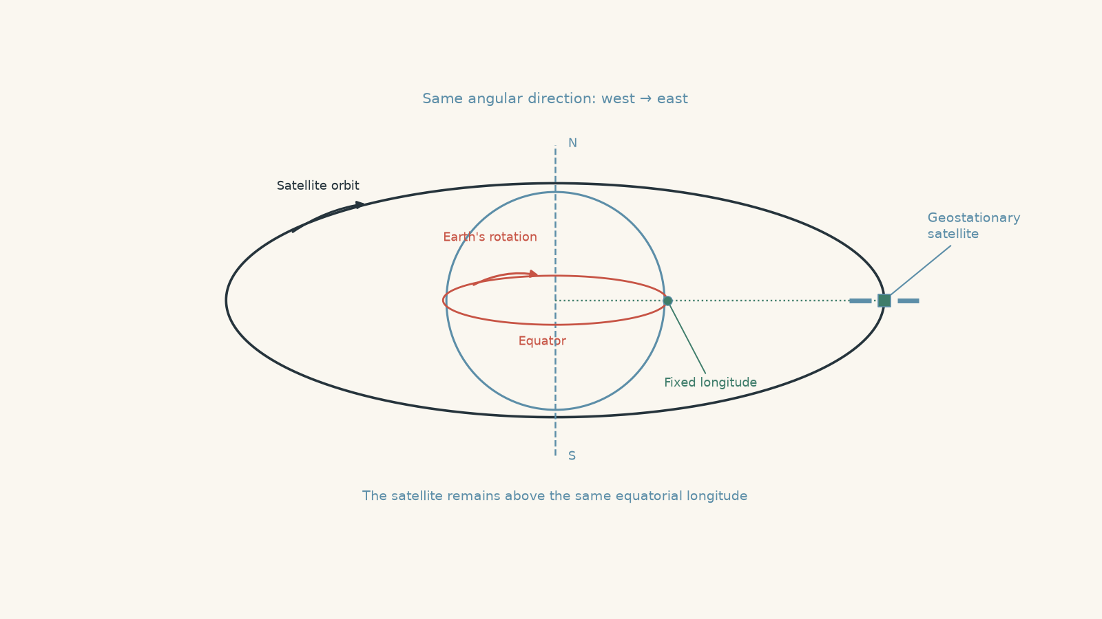
Picture two runners. One runs around the equator on Earth’s surface, while the other runs around a much larger circular track in space. If they keep the same angular speed, move in the same direction, and their tracks line up, the space runner can remain directly above the Earth runner.
That picture gives us the basic idea. The important quantity is not their linear speed. The satellite travels much faster because its circular path is much larger. What must match is their angular motion: both must sweep through \(360^\circ\) in the same time.
The analogy has a limit. A runner can choose any track. A satellite cannot. Gravity determines which orbital paths are physically possible.
02The four conditions for a geostationary orbit
In the ideal HSC model, a geostationary satellite must have all four of these properties:
| Requirement | What it means | What goes wrong if it is not satisfied |
|---|---|---|
| Correct period | One sidereal day, about \(86\,164\text{ s}\) | The satellite drifts east or west relative to Earth |
| Equatorial plane | Orbital inclination is \(0^\circ\) | The satellite moves north and south in the sky |
| Prograde direction | It moves west to east, the same way Earth rotates | It rapidly moves relative to the surface |
| Circular orbit | Orbital eccentricity is approximately zero | Its angular speed changes during the orbit |
A satellite that has the correct period but fails one or more of the other conditions is geosynchronous, but not geostationary.
That distinction is worth keeping clear:
- Geosynchronous means the orbital period matches Earth’s rotation period.
- Geostationary means the satellite also remains above one fixed longitude on the equator.
Every geostationary orbit is geosynchronous. Not every geosynchronous orbit is geostationary.
03The required period is a sidereal day
Here is the first subtle point.
Predict which period a geostationary satellite needs:
- exactly \(24\) hours, or
- about \(23\) hours \(56\) minutes?
It is the second one.
A geostationary satellite must complete one orbit in one sidereal day, approximately
\[ T = 86\,164\text{ s} = 23\text{ h }56\text{ min }4\text{ s}. \]
A sidereal day is the time Earth takes to rotate \(360^\circ\) relative to distant stars.
Our familiar 24-hour solar day is slightly longer because Earth is also travelling around the Sun. After Earth has rotated \(360^\circ\), it must turn a little further before the Sun returns to the same position in the sky.
For most everyday purposes, “24 hours” is fine. For a genuinely geostationary orbit, that difference matters.
04Why the orbital plane must be the equatorial plane
Suppose we give a satellite the correct period but tilt its orbital plane by \(10^\circ\).
Will it still appear stationary?
No. During each orbit, it moves above and below the equator. An observer on Earth would see its position shift north and south, with some accompanying east-west motion.
The orbital plane of an unpowered satellite must pass through Earth’s centre. So if we want the satellite to remain above the same latitude while Earth rotates, the only suitable orbital plane is Earth’s equatorial plane.
This means a geostationary satellite always has an inclination of
\[ i=0^\circ. \]
It also means that a geostationary satellite cannot sit directly above Sydney, London, Tokyo, or any other city away from the equator.
From Sydney, a geostationary satellite can remain fixed in the sky, but its actual position is above the equator.
05Why the direction must match Earth’s rotation
Viewed from above the North Pole, Earth rotates anticlockwise. Equivalently, locations on Earth’s surface move from west to east.
A geostationary satellite must orbit in that same direction. This is called a prograde orbit.
Imagine instead that the satellite had exactly the correct period but travelled east to west. Earth and the satellite would be moving past one another rather than together. Matching the size of their periods would not help.
It is a bit like arranging to walk beside someone at exactly \(5\text{ km h}^{-1}\), then choosing to walk in the opposite direction. Matching speeds is not enough when the directions disagree.
06Why the orbit must be circular
This condition is easy to overlook.
In an elliptical orbit, a satellite does not move at a constant angular speed. It moves faster when it is closer to Earth and slower when it is farther away, as described by Kepler’s laws of planetary motion.
So even if an elliptical orbit takes exactly one sidereal day overall, the satellite gets ahead of Earth during some parts of the orbit and falls behind during others.
Its average period matches Earth. Its instantaneous angular motion does not.
For a geostationary satellite, we therefore use a circular orbit so its distance from Earth and orbital speed remain constant in the ideal model.
07Why there is only one geostationary orbital radius
Once the required period is fixed, the orbital radius is not a design choice.
Gravity provides the centripetal force that continually changes the direction of the satellite’s velocity. For a satellite of mass \(m\), orbiting Earth of mass \(M\) at radius \(r\),
\[ \frac{GMm}{r^2}=\frac{mv^2}{r}, \]
where:
- \(G\) is the universal gravitational constant,
- \(M\) is Earth’s mass,
- \(m\) is the satellite’s mass,
- \(r\) is the distance from Earth’s centre, and
- \(v\) is the orbital speed.
The satellite travels one circumference, \(2\pi r\), during one period \(T\), so
\[ v=\frac{2\pi r}{T}. \]
Substituting this into the centripetal-force equation gives
\[ \frac{GM}{r^2} = \frac{4\pi^2r}{T^2}. \]
Rearranging,
\[ r^3=\frac{GMT^2}{4\pi^2}, \]
so
\[ r=\left(\frac{GMT^2}{4\pi^2}\right)^{1/3}. \]
This is the same period-radius relationship developed more generally in orbital period calculations.
Notice what the equation says. Once we choose Earth and require a particular period, the orbital radius is determined.
You cannot place a natural geostationary satellite at half the usual altitude and simply tell it to orbit more slowly. At that smaller radius, gravity requires a different orbital speed and therefore a different period.
Worked example: Find the geostationary altitude
A satellite is to be placed in a circular geostationary orbit. Calculate its altitude above Earth’s surface.
Use:
- \(G=6.674\times10^{-11}\text{ N m}^2\text{ kg}^{-2}\)
- \(M=5.972\times10^{24}\text{ kg}\)
- \(T=86\,164\text{ s}\)
- Earth’s radius \(R_E=6.371\times10^6\text{ m}\)
Step 1
\[ r=\left(\frac{GMT^2}{4\pi^2}\right)^{1/3} \]
Step 2
\[ \begin{aligned} r &= \left[ \frac{ (6.674\times10^{-11}) (5.972\times10^{24}) (86\,164)^2 }{ 4\pi^2 } \right]^{1/3}\\ &\approx 4.216\times10^7\text{ m} \end{aligned} \]
This is the distance from Earth’s centre, not the altitude above the surface.
Step 3
\[ \begin{aligned} h&=r-R_E\\ &=4.216\times10^7-6.371\times10^6\\ &\approx3.579\times10^7\text{ m} \end{aligned} \]
Therefore,
\[ h\approx35\,800\text{ km}. \]
A geostationary satellite is therefore about \(35\,800\text{ km}\) above Earth’s surface.
That huge altitude is not arbitrary. It is the altitude at which a circular orbit naturally has the required one-sidereal-day period.
Worked example: Is a 24-hour orbit actually geostationary?
A satellite travels eastwards in a circular equatorial orbit with a period of exactly \(24.00\text{ h}=86\,400\text{ s}\). Earth’s sidereal rotation period is \(86\,164\text{ s}\).
Calculate how far the satellite drifts in longitude relative to Earth during one sidereal day.
Step 1
The fraction completed is
\[ \frac{86\,164}{86\,400}. \]
So its angular displacement is
\[ \begin{aligned} \theta_s &=360^\circ\left(\frac{86\,164}{86\,400}\right)\\ &\approx359.017^\circ. \end{aligned} \]
Step 2
During one sidereal day, Earth rotates exactly
\[ \theta_E=360^\circ. \]
The satellite therefore falls behind by
\[ \begin{aligned} \Delta\theta &=360^\circ-359.017^\circ\\ &\approx0.983^\circ. \end{aligned} \]
The satellite would drift about \(0.98^\circ\) west in longitude relative to Earth each sidereal day.
That is why saying “the period is 24 hours” is a useful approximation, but not the precise condition.
08Why geostationary satellites are useful
Their main advantage is simple: from the ground, they stay in essentially the same direction.
Communications and broadcasting
A ground antenna can point towards one fixed part of the sky rather than continually tracking a moving satellite.
That is useful for services such as satellite television and some telecommunications links. One satellite also has a view of a very large fraction of Earth’s surface.
There is a trade-off. The satellite is nearly \(36\,000\text{ km}\) up, so signals must travel a long distance. That introduces noticeable propagation delay compared with much lower satellites.
Weather observation
A geostationary weather satellite can repeatedly observe the same large region of Earth.
That makes it useful for watching changing cloud patterns, storms, and other large-scale weather systems. Instead of seeing a location only when the satellite passes overhead, meteorologists can obtain a continuous sequence from nearly the same viewing position.
Continuous regional coverage
A geostationary satellite does not need to wait for its orbit to bring it back over a region. As long as that region is visible from the satellite’s fixed longitude, communication or observation can continue.
Coverage becomes less favourable towards the poles because the satellite is always above the equator and appears increasingly low on the horizon.
This is also why you should not automatically associate every satellite system with geostationary orbit. Navigation satellites, for example, use different orbital arrangements because their job requires different coverage geometry.
09The misconception to avoid: “Period equals one day, so it is geostationary”
This is probably the most tempting mistake.
A student sees
\[ T\approx24\text{ h} \]
and immediately labels the orbit geostationary.
Instead, run through four checks:
- Does the period equal one sidereal day?
- Is the orbit circular?
- Is it in the equatorial plane?
- Is it prograde?
Only when all four conditions are satisfied is the orbit geostationary.
The period controls whether the satellite can match Earth’s average rotation rate. The other conditions determine whether that match happens continuously and in the correct direction.
10Questions and solutions
Question 1
A satellite moves in a circular orbit of radius \(4.22\times10^7\text{ m}\) from Earth’s centre. Its period is \(86\,164\text{ s}\), its orbit lies in the equatorial plane, and it moves west to east.
Explain whether the satellite is geostationary, and calculate its orbital speed.
Solution 1
The satellite is geostationary, and its orbital speed is approximately \(3.08\times10^3\text{ m s}^{-1}\).
It satisfies the required conditions: its period is one sidereal day, its orbit is circular and equatorial, and it travels in the same direction as Earth’s rotation.
For a circular orbit,
\[ v=\frac{2\pi r}{T}. \]
Substituting,
\[ \begin{aligned} v &=\frac{2\pi(4.22\times10^7)}{86\,164}\\ &\approx3.08\times10^3\text{ m s}^{-1}. \end{aligned} \]
So the satellite travels at about
\[ v\approx3.08\text{ km s}^{-1}. \]
The tempting mistake is to think “stationary” means its velocity is zero. Its velocity is actually several kilometres per second. It appears stationary only in Earth’s rotating reference frame.
Question 2
Three satellites all have an orbital period of one sidereal day and move in the same direction as Earth’s rotation.
- Satellite A has a circular orbit in the equatorial plane.
- Satellite B has a circular orbit inclined at \(10^\circ\) to the equatorial plane.
- Satellite C has an elliptical orbit in the equatorial plane.
Which satellite is geostationary? Describe the apparent motion of the other two relative to Earth.
Solution 2
Only Satellite A is geostationary.
Satellite A has the correct period, a circular orbit, zero inclination, and the correct direction. It can therefore maintain a fixed position above one equatorial longitude.
Satellite B is geosynchronous but not geostationary. Its inclined orbital plane causes its sub-satellite point to move north and south of the equator during each orbit. It therefore traces a repeating path in the sky rather than remaining at one fixed point.
Satellite C is also geosynchronous but not geostationary. Because its orbit is elliptical, its speed and angular speed vary. It moves faster while nearer Earth and slower while farther away, so it alternately gets ahead of and falls behind Earth’s rotation.
The tempting argument is that all three have the same period, so all three should return to the same place. They do return to the same orbital phase after one sidereal day. The missing condition is what happens during the day. Geostationary motion requires the relative position to remain fixed continuously, not merely repeat after one complete cycle.
Question 3
A geostationary satellite is positioned above the same longitude as a ground station at latitude \(34^\circ\text{ S}\).
Take Earth’s radius as \(6.37\times10^6\text{ m}\) and the satellite’s orbital radius as \(4.216\times10^7\text{ m}\).
Assuming a straight-line signal path, estimate:
- the distance from the ground station to the satellite, and
- the minimum one-way signal travel time if electromagnetic waves travel at \(3.00\times10^8\text{ m s}^{-1}\).
Explain why the satellite is not directly overhead.
Solution 3
The satellite is about \(3.71\times10^7\text{ m}\) from the ground station, giving a minimum one-way travel time of about \(0.124\text{ s}\). It is not directly overhead because every geostationary satellite lies above the equator.
The ground station and satellite are at the same longitude, so the angle at Earth’s centre between their radial directions is approximately \(34^\circ\).
Using the cosine rule,
\[ d^2=r^2+R_E^2-2rR_E\cos34^\circ, \]
where \(d\) is the station-to-satellite distance.
Substituting,
\[ \begin{aligned} d &= \sqrt{ (4.216\times10^7)^2 + (6.37\times10^6)^2 - 2(4.216\times10^7)(6.37\times10^6)\cos34^\circ }\\ &\approx3.71\times10^7\text{ m}. \end{aligned} \]
The minimum signal time is
\[ \begin{aligned} t&=\frac{d}{c}\\ &=\frac{3.71\times10^7}{3.00\times10^8}\\ &\approx0.124\text{ s}. \end{aligned} \]
So even before allowing for processing or a return journey, the signal requires about \(124\text{ ms}\) to travel one way.
The tempting picture is that a “stationary” satellite must sit directly above the ground station using it. That is impossible for a natural geostationary orbit away from the equator. The satellite remains above latitude \(0^\circ\), while the ground station is at \(34^\circ\text{ S}\).
Question 4
A satellite travels eastwards in an elliptical orbit lying exactly in Earth’s equatorial plane. Its orbital period is exactly one sidereal day.
At one instant it is at perigee, its closest point to Earth. Half an orbit later it is at apogee, its farthest point.
Without assuming the satellite is geostationary, determine:
- whether it tends to move east or west relative to Earth near perigee,
- whether it tends to move east or west relative to Earth near apogee, and
- whether it can nevertheless return to the same relative position after one complete orbit.
Explain your reasoning using Kepler’s second law.
Solution 4
Near perigee the satellite tends to move east relative to Earth, near apogee it tends to move west relative to Earth, and after one complete sidereal-day orbit it can return to the same relative position.
Kepler’s second law states that the line joining Earth and the satellite sweeps out equal areas in equal times.
Near perigee, the satellite is closer to Earth. To sweep out area at the required rate, it moves through angle more rapidly. Its angular speed is greater than it is near apogee. For an elliptical geosynchronous orbit, this causes it to get ahead of Earth’s uniform rotation during the faster part of the orbit.
Near apogee, the satellite is farther away and its angular motion is slower. Earth’s surface then gains on it, so the satellite appears to move back west relative to the ground.
However, the complete orbital period is still one sidereal day. After the satellite completes one full orbit, Earth has completed one full rotation, so the relative pattern repeats.
The tempting route is to argue:
\[ T_{\text{satellite}}=T_{\text{Earth}} \]
therefore the satellite must remain fixed.
That only compares average motion over a complete cycle. Geostationary motion requires the angular speeds to match at every instant. An elliptical orbit fails that condition because its orbital speed changes continuously.
Question 5
An engineer proposes a different way to place a satellite permanently above a city at latitude \(34^\circ\text{ S}\).
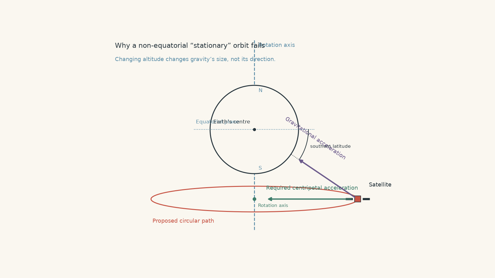
The proposal is to make the satellite rotate around Earth’s axis once every sidereal day in a circular path parallel to the equator, but with the entire circle shifted south. The satellite would therefore remain at latitude \(34^\circ\text{ S}\) and at one fixed longitude.
The engineer argues that an appropriate altitude should make gravity supply the required centripetal acceleration.
Can any altitude make this an unpowered orbit around a spherical Earth? Explain using the directions of gravity and centripetal acceleration, rather than simply quoting the rule that geostationary satellites must be equatorial.
Solution 5
No altitude can make the proposed path an unpowered orbit. Away from the equatorial plane, gravity points in the wrong direction to provide exactly the required centripetal acceleration.
For the satellite to remain above the same point on the rotating Earth, it must circle Earth’s rotation axis with the same angular velocity as Earth.
The centripetal acceleration for that circular motion must point directly towards the rotation axis.
But gravity does something different. For a spherical Earth,
\[ g=\frac{GM}{r^2}, \]
and the gravitational acceleration always points directly towards Earth’s centre.
At an equatorial point, those two directions coincide: the direction towards Earth’s rotation axis is also the direction towards Earth’s centre.
At \(34^\circ\text{ S}\), they do not coincide.
Gravity has a component pulling the satellite towards the equatorial plane as well as a component towards the rotation axis. Changing the altitude can change the magnitude of gravity, but it cannot remove that unwanted directional component.
That is the crucial constraint.
The tempting approach is to compare only magnitudes:
\[ F_g \stackrel{?}{=} F_c. \]
It seems as though choosing the right \(r\) should solve the problem. But forces are vectors. Matching magnitudes is not enough when their directions differ.
This also explains, rather than merely memorises, why the geostationary orbit must lie in the equatorial plane. At the equator, and only there for a non-powered circular orbit of this type, Earth’s gravity points in exactly the direction required to maintain the satellite’s circular motion around Earth’s rotation axis.
A spacecraft could in principle use continuous thrust to hold a non-natural position, but it would no longer be following an ordinary gravitational geostationary orbit.
The next useful step is to connect this ideal picture to real satellites. The period-radius relationship fixes the geostationary altitude, while small gravitational disturbances from the Moon, Sun, and Earth’s non-uniform shape slowly push real satellites away from the ideal orbit. Their thrusters perform station-keeping to correct those deviations. The physics of geostationary orbit therefore gives you the reference orbit; perturbations explain why real spacecraft need continual small corrections.